 NERC Data Catalogue Service
Water management
Type of resources
Topics
Keywords
Contact for the resource
Provided by
Years
Formats
Representation types
Update frequencies
-

Ensemble of simulated groundwater levels for Iloilo, Philippines. The simulated time series of data covers the period December 1979 to December 2089 under two Representative Concentration Pathways (RCP2.6 and RCP 8.5). Each ensemble member csv file contains a timeseries of groundwater levels for thirteen locations within the Iloilo region. The textfile included in the folder shows the coordinates for these locations.
-
Data files and reports from NERC grant NE/L001934/1, Optimizing Road Development for Groundwater Recharge and Retention. 1. Optimizing Intensified Runoff from Roads for Supplemental Irrigation: Tigray Region, Ethiopia MSc Thesis by Meseret Dawit Teweldebrihan 2. Reconnaisance Report: Potentials of water harvesting from road catchments: the case of Freweign-Hawzien-Abreha Weatsbeha route, Tigray, Northern Ethiopia 3. Reconnaissance Report for Water harvesting from roads in Tigray, Northern Ethiopia: Practices, Opportunities and Design Considerations 4. Reconnaissance Report Road development and gully erosion in Ethiopia: Towards the design of multifunctional roads to harvest water 5. Where does the water flow? Roads runoff, soil erosion, groundwater, livelihoods and poverty alleviation in Tigray, Ethiopia
-
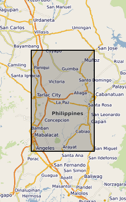
Ensemble of simulated groundwater levels for Central Luzon, Philippines. The simulated time series of data covers the period December 1979 to December 2089 under two Representative Concentration Pathways (RCP2.6 and RCP 8.5). Each ensemble member csv file contains a timeseries of groundwater levels for five locations within the Central Luzon region. The textfile included in the folder shows the coordinates for these locations.